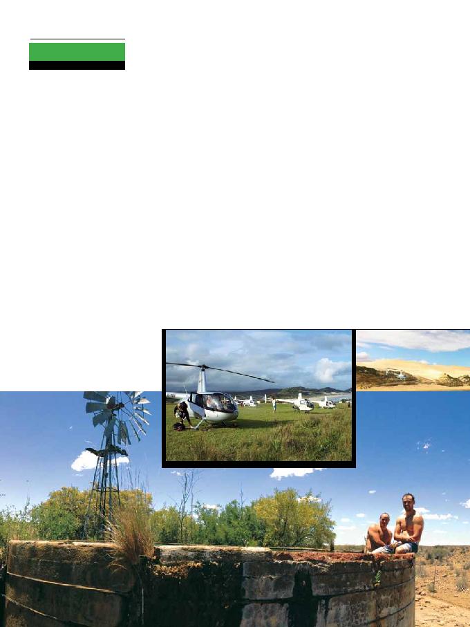
BAC Helicopters
Karoo
Flyaway 2012
There is nothing that can come close
to a cross-country flyaway for sheer
learning value, and no matter how
many hours or how much experience
you may have, every pilot comes away
having grown a little, or grown a lot.
From an instructor's stance, few things
can touch the satisfaction of watching
your students grow and gain confi-
dence and professionalism.
In early December, the BAC
crew packed their bags, loaded the
helicopters and headed for the Central
Karoo. Essentially, this was an
exercise designed for our five pilots
who are building hours and experience
for CPL and it is one that we will
repeat regularly.
The Setup
:
· 3 x RH44 Pilot + 3; MAUW
2,500lbs; Cruise speed 100KIAS;
Endurance 3hrs.
· 2 x RH22 Pilot + 1; MAUW
1,370lbs; Cruise speed 70KIAS;
Endurance 3hrs.
· 2 Instructors, 8 pilots and 1
passenger.
· Distance 1,400nm in 4 days.
· Aircraft flying time: RH22 21,5hrs
& RH44 16hrs.
· Day 1: Durban Mthatha
- Gariep Dam
by Lucy Erasmus - Chief Flight Instructor
Training Trips
· Day 2: Gariep Graaf Reinet
Beaufort West Matjiesfontein
Oudtshoorn
· Day 3: Oudtshoorn Port Elizabeth
East London Wavecrest
· Day 4: Wavecrest Margate -
Durban
The route was determined
mainly by the availability of fuel
and the ability of the helicopters to
cover the distance in-between. After
that, Instructor influence ceased
and the pilots planned the trip,
dividing up the planning duties and
sharing information.
In four days, we experienced every
type of weather mist, rain, hail, blue
sky, thunderstorms, gale force winds,
headwinds, tailwinds, downdraughts
and zero wind. The temperature
ranged between 6 and 37 degrees and
the terrain varied from coastal dunes
to desert scrub and mountain ranges.
From controlled airspace and major
airports to dirt runways and gliding
clubs, everybody grew and this is what
they learned.
Map/Route Planning:
GPS is not enough - It is essential
that each aircraft has on board, the
map or section of the aeronautical
map that pertains to each leg and
the surrounding terrain, and that
the track is clearly marked with as
much pertinent information as pos-
sible. This should include heading,
distances, fuel usage, time markers,
reporting points, frequencies, high
points en route, height of surround-
ing mountains, nature reserves and
minimum heights, FADs, FARs and
FAPs, runway information and even
circuit pattern. In short, study the
map properly if you are flying it,
then it is your responsibility to plan
it. A familiar and well-marked map
can make all the difference to the
decision making process in the event
of a diversion.
Airfield Planning:
If you are planning to fly into an
unfamiliar airfield, whether it be an
international airport or an uncon-
trolled strip, make sure you know
exactly how it operates and, given
the wind direction, which runway
will be in use and what the circuit
procedure will be. The airfields direc-
tory has valuable information about
almost every strip in the country and
it also has a contact number. Phone
the airfield ahead of time to find out
any additional information where
to make initial radio contact and to
whom, how they would prefer you to
approach, where to park and whether
the fuel bowser is mobile or fixed.
Etiquette and airmanship in and
around an airfield is the mark of a
professional pilot
Weather Planning:
It's an unfamiliar region and you
need to know what to expect from
the weather. Besides the SA weather
forecast, TAFs and METARs, use the
Internet to look up typical weather
patterns for the area. This is such im-
portant information and it determines
what time you should plan to take off,
what to expect en route and when you
should be safely on the ground. The
potential for weather change needs to
be factored in, in order to make sound
decisions regarding a diversion or
alternate route for each leg.
Fuel Planning:
Fuel is a critical area of planning that
not only involves distance, ground-
speed and weight, but must also take
into account the temperature and the
terrain to be crossed to anticipate
the power usage for the leg. Always
include contingency fuel in your
planning and have a clear plan for the
point of no return. Constantly calcu-
late the fuel usage as you fly so that
decisions and diversions are made in
good time and are not left for the last
minute. As a back up for potential
headwinds on the longer legs, the
faster RH44s each carried an empty
plastic jerry can so that fuel could
be ferried back to the RH22s if
required. Fuel planning must also in-